Posts

Showing posts from 2018

MAP QUESTIONS NECTA 2015

Image
NECTA 2015: Study carefully the map extract of LEMBENI,sheet 73/3 and then answer the following questions. (a)     Calculate the area covered by seasonal swamps in km 2 (b)    Identify the grid reference of the location of the following features;                                                         i.             Kiverenge School                                                       ii.             Lokira hill (c)     Calculate the distance covered by the loose surface road in kilometers from grid references 509848 to 480816. (d)    By citing   examples from the map , identify the type of vegetation of the area (e)     Describe five usefulness of topographical map to a geographer.

Hatimaye Mahakama Yakubali Mwenyekiti wa Mtandao wa Wanafunzi Tanzania (TSNP), Abdul Nondo Apewe Dhamana

Image
hughulikia dhamana ya mwanafunzi huyo wa Chuo Kikuu cha Dar es Salaam (UDSM). Nondo anatuhumiwa kwa makosa mawili. Kosa la kwanza ni kuchapisha taarifa za uongo mtandaoni Machi 7, 2018 akiwa Ubungo na kusambaza kwa kutumia mtandao wa WhatsApp kuwa yupo hatarini. Shtaka la pili ni kutoa taarifa za uongo kwa watumishi wa umma mjini Mafinga alipokuwa akitoa taarifa katika kituo cha Polisi Mafinga kuwa alitekwa na watu wasiojulikana jijini Dar es Salaam na kupelekwa Kiwanda cha Pareto cha Mafinga. Alifikishwa  mahakamani hapo saa tatu asubuhi akiwa kwenye gari la Polisi kisha kupelekwa katika mahabusu ndogo mahakamani hapo na kuingizwa katika chumba cha mahakama saa 3:45 asubuhi. Kesi imeahirishwa hadi Aprili 4, 2018. Mara ya kwanza Nondo alipofikishwa mahakamani kuliibuka mkanganyiko kwa kisheria kuhusu dhamana baada ya upande wa mashtaka kuomba asipewe kwa maelezo kuwa bado maisha yake yapo hatarini.

PROCEDURES IN MAP MAKING AND ITS LIMITATIONS

Image
PROCEDURE IN MAP MAKING The construction of a map involves the following important steps - a) The cartographer has to make overall plan of a kind of map to be designed. The plan depends on what is intended to appear on the map about the area i.e. the plan can be design topographical map, Statistical map, Thematic map or cadastral map (b) Collection of data from the area to be mapped. The nature of data to be collected depends on a type of map to be prepared For instance; if the plan is to prepare a topographical map, the cartographer would have to collect the general geographical details of both natural and artificial features present in the area Data can be collected by involving the following methods.  Making of the field survey in the area.  By examining the respective vertical aerial photographs.  By examining the respective satellite images.  Data can be delivered from the existing sources tike books and other maps. c) Choice of a scale This has to take into consi

CARTOGRAPHY AND MAP PROJECTION

Image
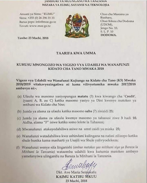
CARTOGRAPHY, Cartography is an art or a science of designing a map to represent either the whole or any part of the earth s surface in scaled and conventional form. There are noticeable contrasts between maps and the whole or parts of the earth s surface represented as follow- - Map is flat, while the earth s surface or part of the earth s surface is not flat. Maps are much smaller in size, while the whole earth or a part of the earth represented is much larger in size With this the map makers use a cartographic technique to maintain the accuracy of the earth s shape and size on maps. The technique is known as map projection It is thus: the cartographic technique is associated with map projection. It is thus: the cartographic technique is associated with map projection as a sole means of maintaining accuracy of areas on maps.  >>>A person responsible in map making is called CARTOGRAPHER. MAP PROJECTION, The earth s surface can be wholly represented with reasonable

KAMA HUKUONA BARUA YA SERIKALI KUHUSU UMRI WA KUJIUNGA KIDATO CHA TANO HII HAPA

Image

necta past papers hizi hapa form ii mpaka form vi

Image
tafadhali copy hii link na upaste kwenye browser kuona necta past papers https://maktaba.tetea.org/past-exams/acsee/

GEOGRAPHER IS BACK

Image
HEY ! GUYS THE FORUM THAT ALWAYS USED TO INFORM YOU DIFFERENT GEOGRAPHICAL EVENTS IS NOW BACK SO YOU JUST COME IN TO SEE WHAT WE DO, I ASSURE YOU WILL FIND VIDEOS, ANIMATIONS AND NOTES ABOUT GEOGRAPHY PLEASE INFORM OTHERS.

Orodha ya Vyuo/Taasisi Zinazoruhusiwa Kufanya Udahili wa Wanafunzi Wapya 2018

Image
Na Jina la Chuo/Taasisi 1 Agency for Development of Education Management (ADEM) – Mbeya Campus 2 AMO Training Centre - Bugando 3 Arafah Teachers' College - Tanga 4 Archbishop John Ramadhan School of Nursing - Korogwe 5 Ardhi Institute - Tabora 6 Ardhi Institute Morogoro - Morogoro 7 Arusha Institute of Business Studies - Arusha 8 Arusha Lutheran Medical Centre School of Nursing - Arusha 9 Arusha Technical College - Arusha 10 Assistant Medical Officers Training College -Mbeya 11 Bagamoyo College of Arts (TaSUBa) - Bagamoyo) 12 Bagamoyo School of Nursing - Bagamoyo 13 Bariadi Teachers College - Bariadi 14 Berega School of Nursing - Kilosa 15 Besha Health Training Institute - Tanga 16 Bishop Nicodemus Hando College of Health Sciences - Babati 17 Borigaram Agriculture Technical College - Dar es Salaam 18 Bugando School of Nursing - Nyamagana 19 Bulongwa Health Sciences Institute - Makete 20 Bulongwa Training Institute - Makete 21 Bustani Te